Together with Helvetic Backcountry, we follow up their 2009 snowboard tour book with a completely new approach to winter sport guides. Backed up by the incredible amount of data they collected over the last years on their endless treks over the alps, we've developed an intricate visual system that allows us to highlight dangers and affordances along a multitude of tours and designed the whole package. Additionally to the Book-Map Package, we developed an App that allows you to filter the Tours that fit to your skills and the current danger of avalanches.
Collaboration with Helvetic Backcountry
year: 2011-2014
The interest in mountain sports is bigger than ever before. More and more people take to alpine touring, and the amount of guides and maps sold is steadily rising. With this positive curve, innovation in the areas of environmental, technical and safety education, and good planning, is paramount. Still, as far as tour guides and maps concern, incredibly little has changed over the last several decades:
– Lack of overview: Many guides (e.g. SAC) provide very detailed information (ascent, exposure, etc.), but it's presented either as tables or in running paragraphs. To contextualise all that data, you have to get the corresponding map, and do a lot of measuring and calculating, which makes the whole process very complex and time intensive.
– Cost: Before the Tourenatlas, maps and guides were always sold as separate products. Every time you want to explore a new area, you have to go and buy the corresponding map, and this quickly adds up.
– Connectivity: Alpine literature generally comes in two flavours – the glossy panoramic photo book, or the dry, technical tour guide. The first waters your mouth, and the second gives you the raw data. If you'd like to have some subjective anecdotes to go with your tour, you'll have to start reading blogs.
Connecting very closely with the authors – professional tour guides with a keen visual eye – we created a core working group of four people, ranging from highly professional to complete newbie, but all with a 200% drive and willingness to put in all the extra hours needed to arrive at what we consider our solution to the above:
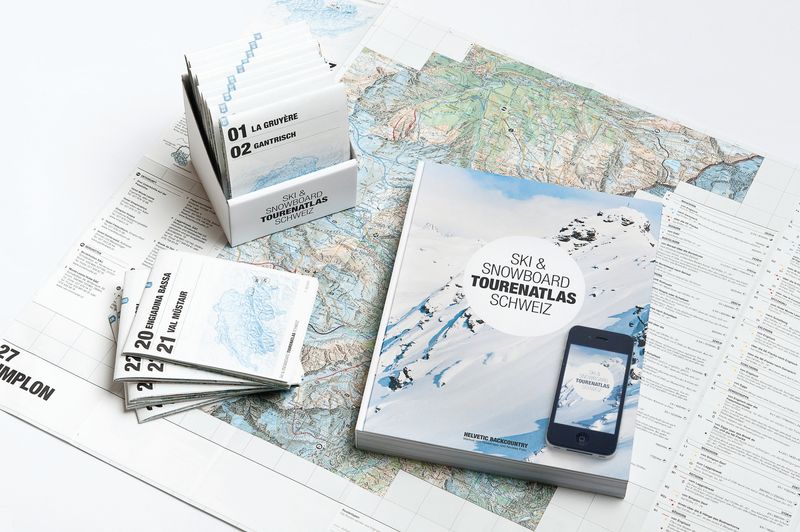
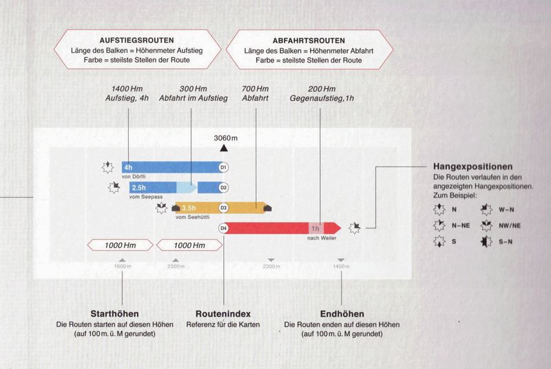
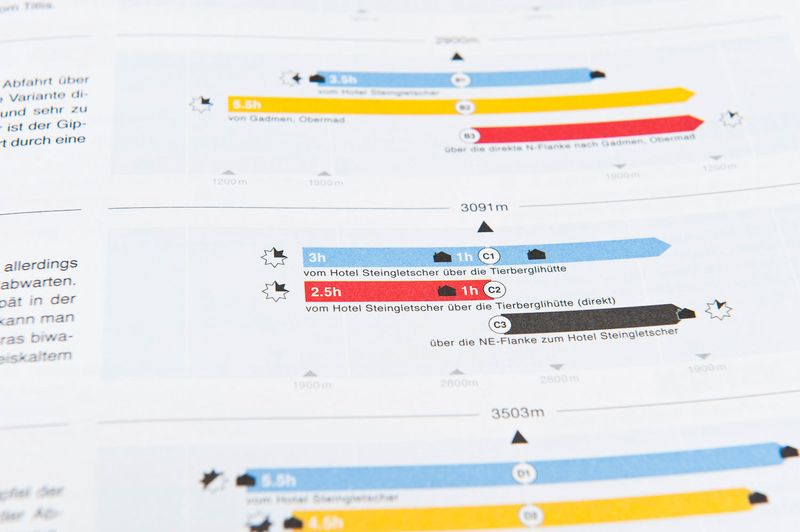
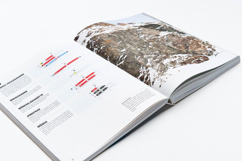
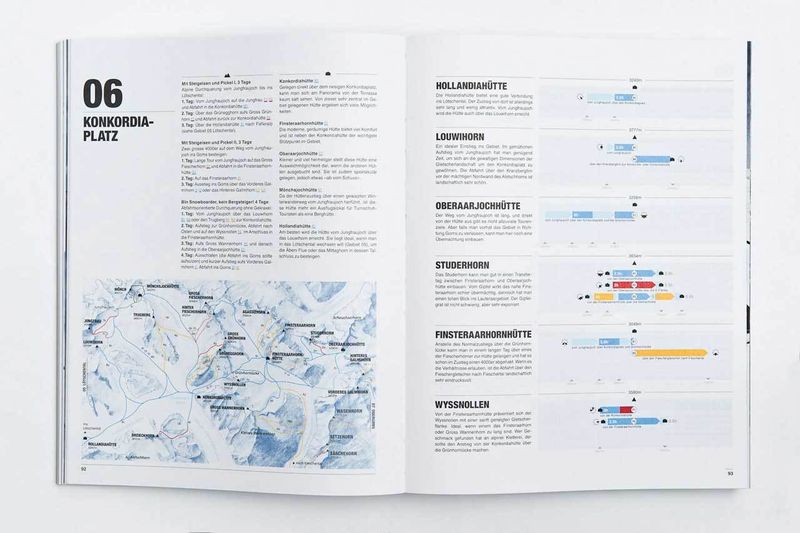
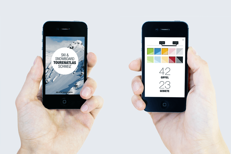
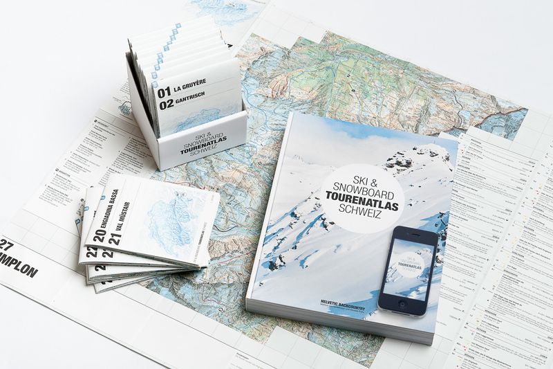
The Ski & Snowboard Tourenatlas Schweiz is a mammoth and an elite gymnast. A package consisting of a book, 30 maps and a mobile app, all of which, in their own way, redefine old patterns: A new map design enables compactness and cost efficiency while adding more detail; A (free) app acting as a portable filter for the 1200+ routes; A book combining beautiful imagery and personal anecdotes with professional tour data. At the heart of everything lies a new kind of peak visualisation, showing you the ascension, steepness, exposure, time estimate and stops for all routes on a single peak.
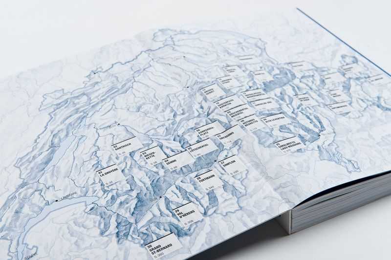
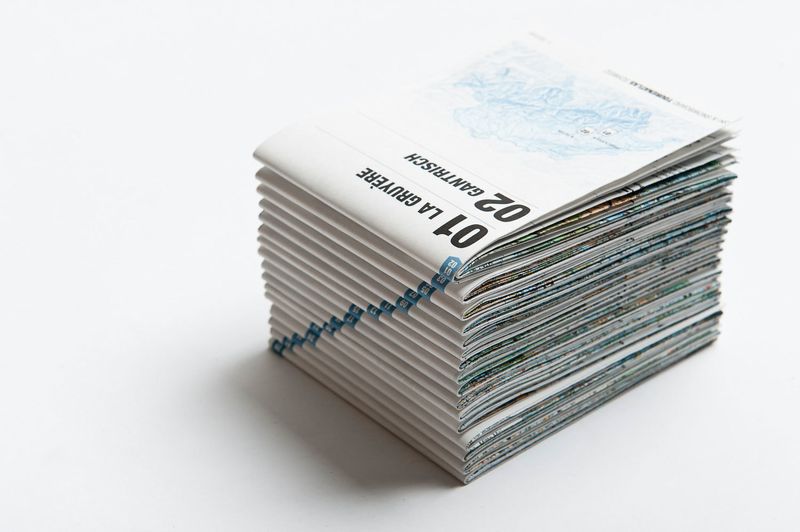
The Ski & Snowboard Tourenatlas Schweiz is a Book-Maps-App package for alpine touring. With 30 areas, 400 peaks and 1200 routes, it covers a significant part of the Swiss alps, and presents it all from three different perspectives, for different situations:
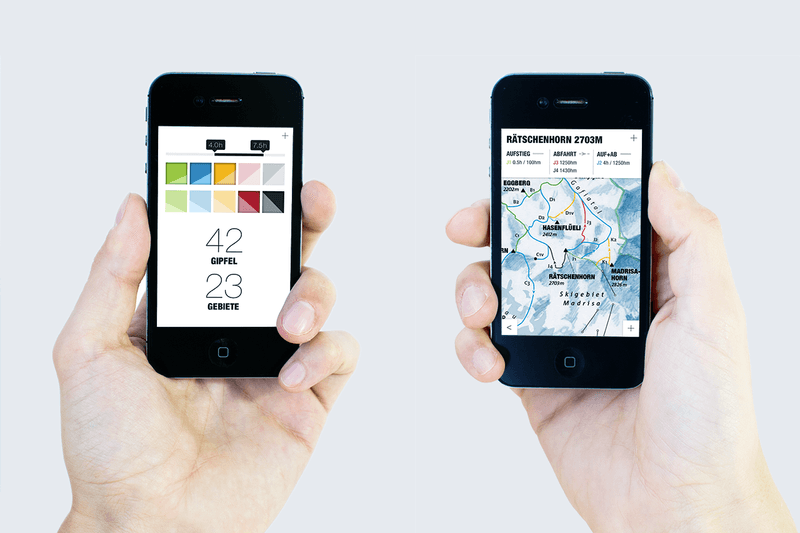
The App, available for iOS and Android, acts as a portable filter. On the go, it makes it easy to spontaneously make a first selection for your weekend tour; enter a desired time and difficulty for your climb and descent, and the Tourenatlas app will give you a list of suitable areas and peaks to visit, listed by their distance from your current location. Selecting an area gives you a preview, with an overview map, a short description to each filtered peak, and a selection of photos to give you a first impression.
Once you arrive at home, the Book contains detailed descriptions for each area, complete with winter photography, infrastructure and logistics information, hand-painted overview maps and personal anecdotes from the authors. To that, route data for each peak within an area is listed using a clear and accessible form of diagram. Gone are the days of getting lost in complex tabular data, invisible hight curves and measuring instruments; among other things, these diagrams show you, at a glance, the entry, exit and peak elevations, the estimated climb time, the steepness of both climb and descent and route exposure. In your living room or on your kitchen table, this book provides all you need for proper tour planning, along with interesting impressions about the available areas.
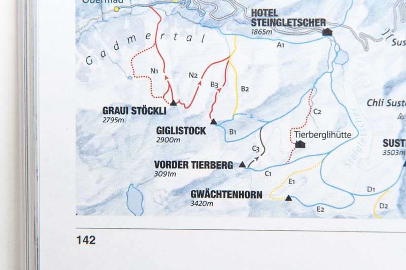
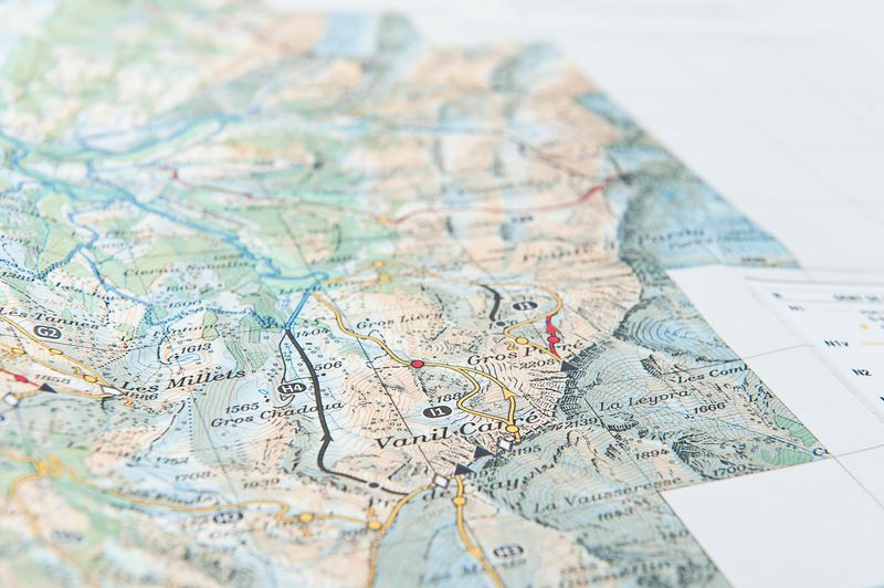
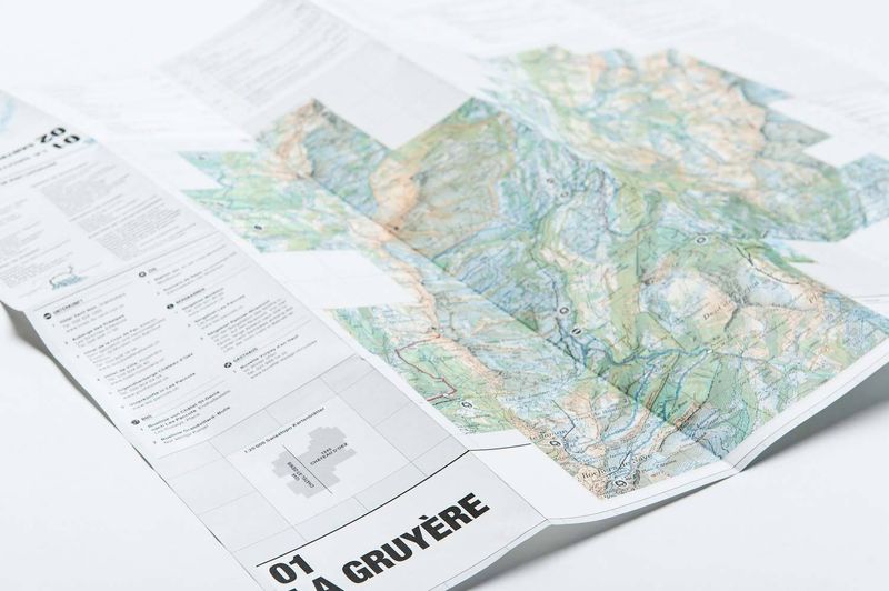
The Maps provides a detailed view when out in the snow. Delivered together with the book, the 30 maps comes with a foldable box for easy access when resting in your book shelf. The paper is especially developed for durability and water resistance. The imagery is industry standard high-detail Swisstopo maps with a detail of 1:35'000, with an added layer of routes. In contrast to conventional tour maps, this route layer also shows levels of difficulty, and a total of 1600 carefully researched key points – tricky situations like the passing of ravines or highly exposed areas.
This combination of zoom levels, together with the premiere of difficulty colour grading and the compact peak visualisations, results in a completely new access to alpine touring. After almost 3 years of hard work in a very small core team, we are very proud and happy to feel the reception of the Tourenatlas, and we're looking forward to see what happens next.
After about 2,5 years of gathering data, conceptualising, designing and developing, the Ski & Snowboard Tourenatlas Schweiz was officially born into the world through a vernissage on November 1st, 2013, in Zürich. For this launch, the authors – Nicolas Fojtu and Markus von Glasenapp from Helvetic Backcountry – founded their own publishing house. Although very proud and convinced about our product, the response was staggering; the first edition, 3000 books, was sold out within two months. Orel Füssli placed it on their bestseller list, and the response from both media and the big players in the ski/snowboard tour industry was overwhelmingly positive; SAC called our approach "a milestone" for alpine tour planning.
And the story continues; In fall 2014, Räthische Bahn started featuring maps and directions for tours from the Tourenatlas with connection to their network, and renowned tour magazine Höhenfieber has introduced special markers for those of their tours which can also be found in our package.